
Location: Pembroke, Maine, and Baltimore, Maryland
Editor’s note: Photos and art pieces are by the artist unless otherwise indicated.
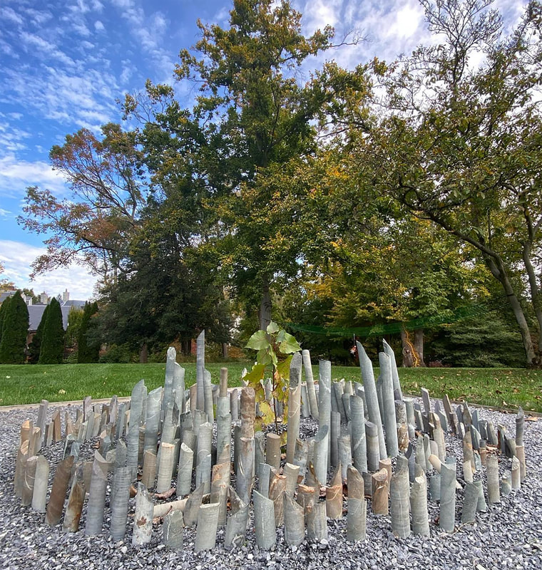
Gold Rush (detail), rock core samples extracted from Maine/Passamaquoddy-land, metal beams, and scrolling LED sign, 120″ x 120″ x 120″, Hamiltonian Gallery, Washington, DC, 2022. Photo: Vivian Marie Doering, courtesy of Hamiltonian Artists.
I. Introductions
In June 2021, I responded to a different sort of juried call. Smithereen Farm and Greenhorns, Inc. were offering 20,000 mined rocks to be used for art.1,2 As an environmental sculptor, I was smitten. Immediately drawn to the science, history, and cultural context of natural materials, I headed north from my Baltimore, Maryland studio to Pembroke, Maine—population 788. Located a few miles south of the Canadian border, rolling hills with towering pines framed pebbled roads of the downeast town. Ebbing tides revealed muddied inlets as I circled the Cobscook Bay coastline.
During my first visit to the 1800s lodge owned by Smithereen Farm, I learned that Wolfden Resources Corporation had recently received permission to conduct exploratory mining at Big Hill Mine. Wolfden, a junior mining company based out of Canada, relies on venture capital to secure financing for surveying initiatives. The company would be the third to dig for silver and gold in the same spot since the 1850s, but the original collection of rock-core samples from the Gold Rush days was locked in the Smithereen Farm lodge basement. The founder of both Smithereen Farm and Greenhorns Inc., Severine von Tschering Fleming Welcome, had acquired the land and several properties in the town with the vision of building an environmentally and economically sustainable community driven by agriculture.
Shaft (installation view), 30 hand-carved wooden core trays, overall 60″ x 180″ x 36″, Hamiltonian Gallery, Washington, DC, 2022. Photo: Vivian Marie Doering, courtesy of Hamiltonian Artists.
I followed Severine down rickety wooden steps past a cow skull, an oil lamp, and flickering daylight. I’d driven 14 hours in a bouncing box truck, so I was excited to touch ground. A long hallway lined with fluorescent lights was filled with rows of numbered wooden boxes, stacked floor to ceiling, and piles of decaying trays holding cores of stone, collapsing onto each other. It was a catacomb. The air felt heavy as we passed the woodworker’s cage, complete with rusted oil cans and wood-dusted rasps, where core trays were once carved by hand. Pushing cobweb curtains aside, my fingers drew against splintered wood and gravel mounds. I could almost grasp the cores’ three-inch diameter, but their edges were jagged from extraction, the impact of being removed from their original subterranean location, and jostled along their journey.
The cellar door slammed closed. No one else was in the lodge, so I assumed it was the chemical release of the gas or spirits, or Time edging us forward. We stepped over fallen stones, seemingly leaning upwards to fresh air. At dinner, I heard stories about break-ins, changing lodge locks three times in one winter, and visits to the farm by Wolfden representatives. They wanted the samples. One farm employee, in hopes of deterring the mining company, had emptied 50 trays of rock cores and removed their labels. No numbers, no locations. Only one person held the map key that linked the labeled cores to their colonial extraction holes.
The mine was on unceded Passamaquoddy land. I had been gifted Donald Soctomah’s Passamaquoddy at the Turn of the Century, which contained ledgers of the state land transactions.3 It included the text of Tribal Representative Lewis Mitchell’s speech to the Maine Legislature, which showed the land was sold without representation in 1836. Afterwards, the tribe was divided into two locations: Indian Township and Pleasant Point/Sipiyak, about 70 miles apart. On Google Maps, the land is marked by a gray tone, not green like other cities or blue like bodies of water. The Sipiyak reservation is a figure-eight swatch of land cushioned between Cobscook Bay and Passamaquoddy Bay. Tourists only know that it’s close if they catch glimpse of a stone labyrinth nestled beside the freeway or notice the Passamaquoddy fishing weir, 20 feet in diameter, rising off the shoreline.
II. Bay Bounty
Eel trap on the Pennamaquan River, Maine.
Cobscook Bay boasts some of the largest tidal changes in the world, averaging 20 feet and leading into the Bay of Fundy. The tidal changes support an extraordinary diversity of marine species, which drives culture and economy in this most eastern region of the United States, first to see the morning sun. The bays feed inland rivers and streams, presenting a bounty for clammers and local fishermen. During a visit in spring 2022, I waded through river waters as locals were positioning large eel traps. These Indigenous-designed, cornucopia-shaped traps sank halfway beneath the water level (at my thigh), then fully submerged when high tide arrived. Locals gathered the transparent, miniature eels and were paid to ship the “glass eels” to Japan to be raised and harvested. During a visit to Cobscook Bay at low tide, I met a 75-year-old clammer, Edward, who had spent Mondays through Saturdays collecting clams at the ridge of towering pines against craggy shores for 60 years. He was an expert. Circadian rhythms linked to the tides, Edward proudly shared that he’d made $275 a week pulling clams and paid off his house in 12 years.
III. Artifacts of Displacement
Shift: Steel, extracted mine cores from Maine 2′ x 2′ x 8″, 2022.
When I visited the Pleasant Point/Sipiyak reservation, which bordered the mine area, I met Dwayne Tomah. He spoke of his ancestors’ forced separation into Passamaquoddy Indian Township and Pleasant Point Reservations, the division of land and shared dependency on natural resources, and the dedication to preserving language through community. His daughter was helping him with a Passamaquoddy language digitization project.
As a young girl, I gathered rocks on stream expeditions with my dad. He lent me his childhood cigar-box collection of stones and fossils for school show-and-tell. The palette was mesmerizing: ochres, burnt crimson, and smooth cloud colors of gray, blue, and pink streaked with white. I marveled at original shapes and imagined my father’s paths through the stories he shared.
Now, I reflected and considered the irony of bringing rocks into a formal gallery space. The mined rock collection harnessed the union of history, science, economy and culture to transport the viewer, emphasize the impact of accumulation, and create a surreal landscape.
Rocks are evidence of location, space: the conglomeration of water, shifting tectonic plates, humanity’s ruffling, and silt sifted through rivers with time to harden. The rock removal through mining was displacement. The remaining holes marked irreplaceable land, like caterpillar bites through an oak leaf. These particular cores represented the agony of exploited expectation, vacant defeat, and irreplaceable resources. These mined rocks were housed from the initial sampling of the land as resting artifacts of decades of speculation.
In turn, mining business patterns follow a boom and bust cycle. The economy, environment, and culture are often devastated when a mining company vacates town. In Maine/Passamaquoddy territory, the land surrounding the mine was left with felled timber fields, bulldozed habitats, and poisoned water from mining chemicals. The 2023 United States total value of industrial minerals production was $63.5 billion, a 10 percent increase from 2021.4 Half of the total value of industrial materials (more than $31 billion) was production of construction aggregates—sand and gravel and crushed stone.5 Crushed stone accounted for 21 percent of the total value of U.S. nonfuel mineral production.6 Driving past East Coast rock and gravel pits is common, and locals deafen to the dump truck rumble parading through their streets.
When I spoke with Mr. Tomah, he emphasized the values and traditions of the Abenaki-Penobscot-Maliseet tribes that rely on the region’s ecosystems. Water, central to survival in all contexts, drives the economy in this region. The Big Hill Mine location was situated at the aquifer for Pemboke, five surrounding towns, and both reservations, and the surface mining and sampling from the 1980s was still impacting this water supply.
IV. Mine, All Mine
On my first visit, I followed a Smithereen Farm employee down the public road to the mining site. My expectations were based on historical photos, lithographs, and YouTube. Swarms of mosquitoes blinded me. There were jagged rocks with blade cuts and hollowed insides piled 20 feet high. I kept shifting rocks, believing I would reveal a large entrance. However, the original mine was a surface mine. I searched fruitlessly for a shaft leading to a larger room, like in the movie The Goonies or Harry Potter’s underground bank, Gringotts.
I was distracted by a 20-foot-high pile of deep crimson, blood orange rocks with embedded streaks of teal. I gathered a handful and later asked my geologist advisor and experts from Urban Soils Institute about them. When these mined rocks are above ground and exposed to weathering (sun, rain, snow), iron oxides are produced. The reaction of sulfuric acid and dissolved iron can lead to acid runoff, which can dissolve heavy metals like lead, copper, and mercury.7

Gold Rush, rock core samples extracted from Maine/Passamaquoddy, metal beams, and scrolling LED sign, 120″ x 120″ x 120″, Hamiltonian Gallery, Washington, DC, 2022. Photo: Vivian Marie Doering, courtesy of Hamiltonian Artists.
In 2022, legislation was passed to allow the Passamaquoddy tribe to tap into the Perry groundwater aquifer, which also supplies water to towns Lubec, Perry, Eastport, and Whiting.8 The Sipiyak reservation was previously dependent on water supply from Boyden Lake, which had a longstanding history of poor water quality.9 The towering showcase of chemical baubles that I’d encountered was at the heart of the aquifer.
The second company to tap the land, Golden Hope, Inc., surveyed the area in the 1970s and added to the pile. The company declared bankruptcy, stopped tax payments on their building, and left remediation of the land to the taxpayers. Literature associated with their investments read:
As I continued my hike onto the nearby public path, I passed a muddy pit covered with white-flakey chemicals that had broken wooden mine signage in it.
On my second visit to the mine, I got lost. Severine mentioned that the neighbors on the other side of the mine were selling their land to the paper mills. They had their land appraised and their timber assessed for market value, since harvesting mature trees can generate income. For instance, based on the 2023 Maine Stumpage Report, the average sugar maple was listed at $274—with a maximum of $620.11 I was thinking about numbers as I attempted to retrace my path through the trees. When I followed the path to its end, I emerged from the forest into a post-apocalyptic setting. As far as I could see, acres and acres of trees had been plowed. There were two pyramid-like stacks of trees memorialized in the distance. I stumbled past bulldozers with wheels twice my height, in awe of their dinosaur-like footprints in the mud. I turned around.

Assembly, pigment made from ground mined rock cores, earth, calcium hydroxide (lime), 10″ x 14″, 2022.
Between visits, I escaped to my studio in Baltimore, Maryland, to experiment with the cores. I would clank them, listen. Grind them, smear. Play with their magnetic tug, pull. Pile, suspend, count, sort. I made core pigment paints and juxtaposed them with calcium hydroxide to create sweeping visual canvases to bear witness to the interactions. I mixed sap with fine core powder to recompose cores, shaped like Georgia O’Keefe’s homemade pastels. I investigated the dust of earth.
As my exhibition traveled and the artworks evolved, I felt it was critical that visitors connect to the themes of land claim, labor, and permanence, regardless of their location. I wanted visitors to contemplate the propriety and use of natural resources. The commodification and link to power. At all of my exhibitions, I provided a QR code for visitors to download a free metal detector app on their cellphones. In this way, visitors could engage in their own gold rush by hovering over the core artworks to seek precious metals. By using cellphones, which are dependent upon lithium as a battery energy source, viewers could connect the past histories of core removal with the current conversation about demand for lithium mining.
V. Community Bonds
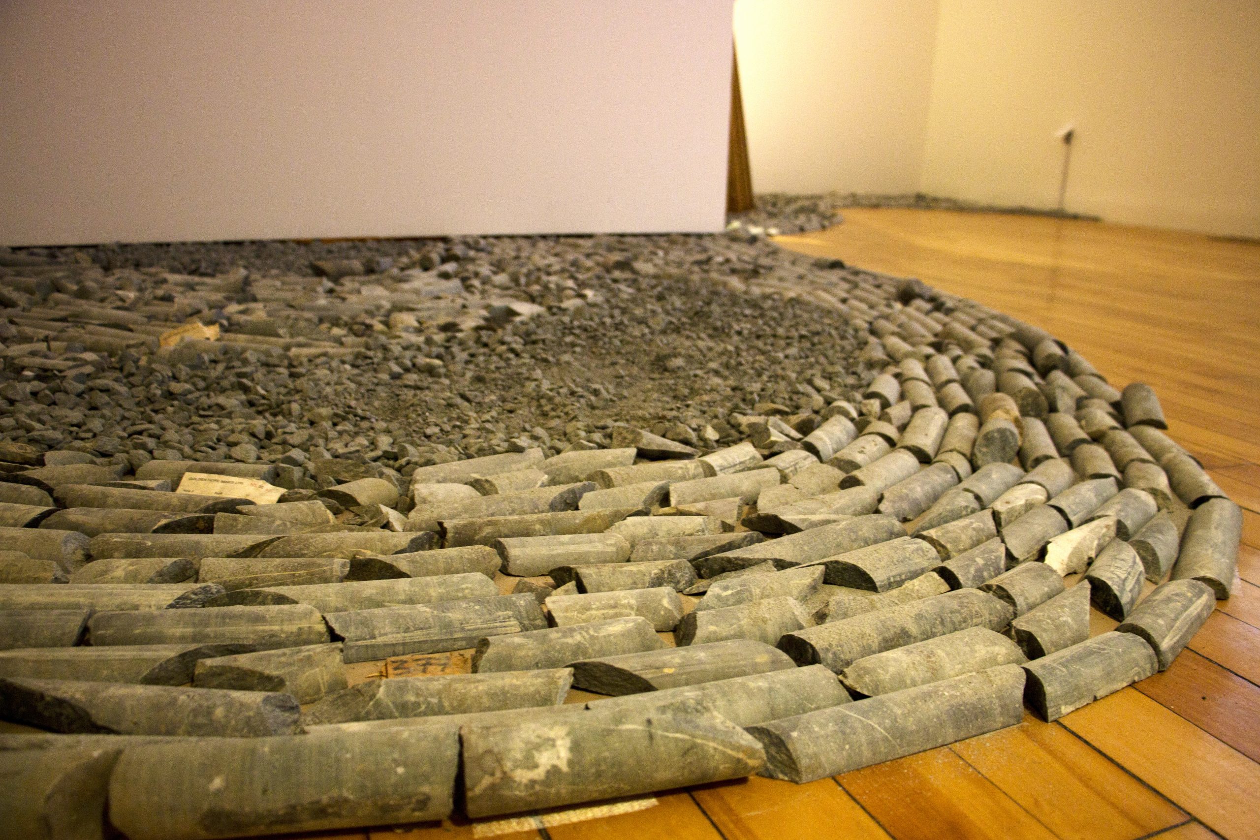
Void II (installation view), extracted mine cores from Maine/Passamaquoddy land, 10′ x 10′ x 3′, The Kreeger Museum, Washington, DC, 2022.
In May 2023, the citizens of Pembroke crowded into the town office, where town clerk Janice Scanlon had served for 40 years. The citizens voted 128 to 48 in favor of an ordinance to prohibit industrial-scale metallic mineral mining operations and set new parameters for community mining projects. When I interviewed Janice later, she said, “I don’t know what’s all the bother is about. They’re not mining, they’re just exploring.”
For me, the town vote redefined the intersection of community and artwork. In addition to co-founding Greenhorns, Inc. and Smithereen Farm, Severine co-founded the National Young Farmers Coalition and spearheaded a grassroots effort that involved church dinners, neighbor visits, school suppers, and resource hall gatherings.12 Chatting. Face to face. Just one or two handwritten flyers were posted, but watching the collective impact of community organizing was like watching an orchestra play a symphony.
The most recent digging at Big Hill by Wolfden coincided with my starting the project in 2021. In my exhibitions, I strung a neon stock ticker sign for the daily stock value of gold, silver, and copper. The sign is representative of how junior mining companies, like Wolfden, hope to flip the land and stocks to sell quickly to an international mining company. The artworks explore the questions: What do we commodify, and how do we assign value? If mined rocks and contemporary art hold commodities, can their fluctuations be assessed, scrutinized, and considered by the viewer? The art, in its truest definition, has been a performance piece. The movement of the cores. A study of labor, claim, and time.
Through the support of The Maine Humanities Council and Margaret E. Burnham Charitable Foundation, I assembled a panel to discuss mining. Voices from the land. Charles Loring (director of natural resources, Penobscot Nation), Nicholas Lund (Maine Audubon advocacy and outreach manager), Jan Morrill (Earthworks tailing campaign manager), Nickie Sekera (co-founder of Community Water Justice), and Bruce Taylor, M.D. (public health physician) tackled all facets of Maine mining. Riveting data and insights cast light on the complexity of navigating the use of natural resources.
I revisited the mining area with a local later that summer. The ordinance had passed, and it appeared that the third mining company had left town. We found their drilling holes. They were three inches wide, each set in the middle of a circular area, 50 feet in diameter, that had been cleared of trees. The positioning reminded me of a breast, of Mother Nature, and the seeping of her milk. Straw bales had been spread unevenly across the craters, with spring grasses poking upwards. Ten-foot steel tubes lined the perimeters, with plastic bag gates cordoning off parts of the forest. We walked to four different sites before we stumbled upon the last one. There, in the center of a mound, we found a steel hole. It had been plugged with a pine tree that, at that point, held needles that were half brown and half green.
V. Untraveled Roads
under/current (installation view), rock core samples extracted from Maine/Passamaquoddy land, University of Southern Maine Art Gallery, 2024. Photo credit: John Harlow
En route to my next exhibition at the University of Southern Maine, I pass a parking lot of bulldozers and backhoes. It’s negative 11 degrees Fahrenheit. I think of my adventures in this small snowglobe region of Maine, where the tree canopy provides a magical umbrella above creeping rivers, moose and minnows, and marauding maps.
At the exhibition installation, I place a rock at the edge of a steel rod, shift the sculpture, tilt the lighting, and step back. There’s the sculpture. Will it grab the viewer? Will they listen to the public programming lecture? Or the panel I pulled together of geologists, land conservationists, physicians, naturalists, and tribe members? I get to play The Artist. When day is done, does the rock remain or do the words? How can one sculpture tell this story? How can one sculpture amplify Nature’s voice? There are always more questions and differences in perspectives, but one planet.
Whether on display or shelved for centuries, the cores are artifacts of claim, commodification, and labor. Counting, order. Numbers and systems. They symbolize the parallel hierarchy found in geological organizational methods, stock market flips for metals, and cultural and political power structures embedded deep into the land.
The cores represent void. Space that cannot be filled with water, rock, or root in the wake of humanity’s interference. Permanent loss. The rocks are the individual words of the Passamaquoddy language that Dwayne Tomah and Donald Soctomah are working tirelessly to preserve. They are the acreage of pine trees bulldozed for paper mills and drill holes. They are night stars spotted above lakes forming a celestial map. And they are our footsteps.
ENDNOTES
- “About,” Smithereen Farm, accessed September 10, 2025, https://www.smithereenfarm.com/about/.
- “About,” Greenhorns, accessed September 10, 2025, https://greenhorns.org/about/.
- Donald Soctomah, Passamaquoddy at the Turn of the Century, 1890-1920 (Passamaquoddy Tribe of Indian Township, 2002).
- U.S. Geological Survey, “Index of /pubs/periodicals/MCS2023,” accessed August 30, 2025, https://pubs.usgs.gov/periodicals/mcs2023/.
- U.S. Geological Survey, “Crushed Stone Statistics and Information,” National Minerals Information Center, 2023, accessed August 30, 2025, https://www.usgs.gov/centers/national-minerals-information-center/crushed-stone-statistics-and-information.
- U.S. Geological Survey, “Index of /pubs/periodicals/MCS2023,” 2024, accessed August 30, 2025, https://pubs.usgs.gov/periodicals/mcs2023.
- Glenna Thomas, Craig Sheridan and Peter E. Holm, “A Critical Review of Phytoremediation for Acid Mine Drainage-Impacted Environments,” Science of the Total Environment 811 (March 2022): 152230, https://doi.org/10.1016/j.scitotenv.2021.152230.
- “As PWD Water Quality Improves, Efforts Aim to Build Trust,” The Quoddy Tides, September 9, 2022, https://www.quoddytides.com/as-pwd-water-quality-improves-efforts-aim-to-build-trust.html.
- “As PWD Water Quality Improves, Efforts Aim to Build Trust,” The Quoddy Tides, September 9, 2022, https://www.quoddytides.com/as-pwd-water-quality-improves-efforts-aim-to-build-trust.html.
- Quoted in Resist Mining in Maine, “Big Hill, Pembroke,” last modified May 2023, https://www.resistmainemining.org/mining-in-maine/big-hill-pembroke-maine/.
- Maine Department of Agriculture, Conservation and Forestry, Maine Forest Service, Forest Policy and Management Division, 2023 Stumpage Prices by Maine County/Unit, Forest Service Documents 324 (December 20, 2024), https://digitalmaine.com/for_docs/324.
- “About,” National Young Farmers Coalition, accessed September 10, 2025, https://youngfarmers.org/about/mission-and-vision/.
WEAD MAGAZINE ISSUE No. 15, PLACE SETTINGS
Published 2026